
 Contact


2000 Combined census of motor traffic and inventory of standards and parametres on main international traffic arteries of Europe = Recensement 2000 de la circulation motorisée et inventaire des normes et des paramètres principaux des grandes routes de trafic international en Europe
Making and printing of a map of the European transit census at 1:5,000,000 scale and ten enlargements at 1:1,500,000 and 1:2,500,000 scales of different geographic areas of Europe. The thematic information of the traffic has been elaborated by the Institut d'Estudis Territorials and has been combined by the Institut Cartogràfic de Catalunya on a his cartographic database, with information about the main communication routes, the main population nuclei and the administrative divisions (box with 11 maps).
Institut Cartogràfic de Catalunya (ICC); Institut d'Estudis Territorials (Generalitat de Catalunya), Barcelona, Spain; Universitat Pompeu Fabra, Barcelona, Spain.
Financed by: United Nations, Economic Commission for Europe, Transport Division, Geneva, Switzerland.
Topographic cartography 1:100,000 for the Argentinian Republic (2000-2004)
The aim of this project, of four years duration, is to produce topographic cartography at 1:100,000 scale of 40% of the territory of the Republic of Argentina (approximately 1,000,000 km2), with a total of 728 sheets. The numerical cartographic database will be compiled and produced at a reference scale of 1:100,000; provision will be made for a structured database with toponomastic information, a geographic information system that will store and manage the entire digital cover of the country, and computer equipment with the corresponding programs to install a geographic information system with military applications for the Argentine army; and computer equipment will be supplied to implement an airway map production system, a cartographic output generation system of limited production, and a primary data capture system on board an airplane that will provide georeferenced multispectral information. The project includes transfer of technology to the IGM, in order that it may complete the production of this cartography in Argentina; for this purpose, the production line will be set up, a complete system with the software package of the ICC will be installed, and the IGM technicians will receive training.
Institut Cartogràfic de Catalunya (ICC); Instituto Geográfico Militar of Argentina, Buenos Aires, Argentina.
Financed by: Instituto Geográfico Militar of Argentina, Ministerio de Defensa, Buenos Aires, Argentina.
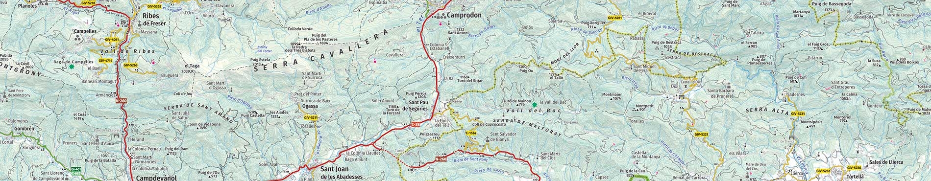
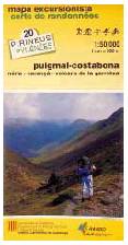
Tourist maps of the Pyrenees at 1:50,000 (1999-2001)
A joint publication devoted to cross-border cartographic cover of the Pyrenees at 1:50,000 scale, conceived as a series of thematic maps of interest to hikers that aim to cover various sectors of the southern slopes of the Pyrenees on 5 sheets. These sheets correspond to the following sectors: Andorra-Cerdanya-Pedraforca-Cadí-Moixeró; Pica d'Estats-Aigüestortes National Park-Val d'Aran; Aneto-Posets-Valle de Bielsa; Balaitús-Vignemale-Monte Perdido-Ordesa National Park, and Roncal-Ansó-Hecho-Pic d'Orhy-Bisaurín.
Institut Cartogràfic de Catalunya (ICC); Randonnées Pyrénéennes, Tarbes-Ibos, France.
Financed by: Institut Cartogràfic de Catalunya (ICC); Randonnées Pyrénéennes, France.
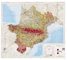
Agroecological zoning in Namibia (1998-2000)
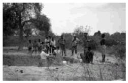
The participation of the ICC in this cooperation project consists in producing the cartography of Namibia at 1:1,000,000 scale (615,000 km2), the NE region of the country at 1:250,000 scale (190,000 Km2) and three areas of special interest at 1:100,000 (20,000 km2), as well as introducing the data obtained into a GIS. The cartography will be produced through the interpretation of Landsat-TM satellite images and aerial photographs. In order to locate control points for the adjustment of the image correction model, the ICC has acquired the topographic cartography of the country at 1:50,000 scale.
Institut Cartogràfic de Catalunya (ICC); Ministry of Agriculture, Water and Rural Development, Namibia; The National Planning Comission, Namibia; Spanish Agency for International Cooperation.
Financed by: Spanish Agency for International Cooperation.
Maps of the 1995 European traffic census (1997-1998)
The aim was to complete a map of the European traffic census at 1:5 000 000 scale and ten enlargements at 1:1,500,000 and 1:2,500,000 scales of various geographic areas of Europe. The traffic information is available on a database with information about the main communication routes, the main population nuclei and the administrative divisions as they existed in 1995.
Institut Cartogràfic de Catalunya (ICC); Pla Territorial Metropolità de Barcelona, Departament de Política Territorial i Obres Públiques (DPTOP) of the Generalitat de Catalunya, Barcelona, Spain.
Financed by: United Nations, Economic Commission for Europe, Transport Division, Geneva, Switzerland.
Topographic map and orthophotomap of Andorra 1:5,000 (1997-1998)
Obtaining of a base of three-dimensional numerical cartographic material covering the 64,752 hectares of Andorran territory and a strip of 50 metres from the border into the territory of the neighbouring states. To complement the project 74 orthophotomaps have been generated on the same scale, covering the entire area of Andorra, from a flight in colour at 1:16,000 scale.
Institut Cartogràfic de Catalunya (ICC); Ministeri d'Ordenament Territorial (Govern d'Andorra).
Financed by: Ministeri d'Ordenament Territorial (Govern d'Andorra).
Topographic map of the Republic of Venezuela 1:250,000. Caracas NC 19-8 (1996-1997)
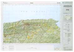
Production of the first digital sheet of the Topographic map of the Republic of Venezuela. In order to accomplish this, photointerpretation was made of images captured by the Landsat satellite during January and February 1994. The contours, 100 m apart from one another, and the relief shading were produced with the help of the Caracas elevation database.
Institut Cartogràfic de Catalunya (ICC); Servicio Autónomo de Geografía y Cartografía Nacional (SAGECAN), Caracas, Venezuela.
Financed by: Servicio Autónomo de Geografía y Cartografía Nacional (SAGECAN), Ministerio del Ambiente y de los Recursos Naturales Renovables, Caracas, Venezuela.
Geological map of Paraje Castaño Nuevo 1:100,000 (Argentina) (1995-1998)
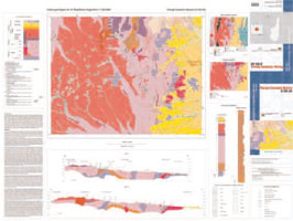
Completation of the geological cartography of Argentina on one sheet at 1:100,000 scale. The first step in order to be able to produce the basic cartography necessary was to produce an orthoimage of the study area at 1:100,000 scale from a SPOT satellite image. Therefore, some field points were confirmed, the parameters defining the geometry of the sensor were adjusted and the initial image was constructed. At the same time, the necessary field work was completed. A geological synthesis at 1:100,000 scale was extracted from both sources of data.
Institut Cartogràfic de Catalunya (ICC); AURENSA, Madrid, Spain.
Financed by: Subsecretaría de Minería de la Nación of the Secretaría de Industria, Comercio y Minería of the Government of Argentina, Buenos Aires, Argentina.
Topographic map of the Argentinian Republic 1:250,000. San Nicolás de los Arroyos (1995-1996)
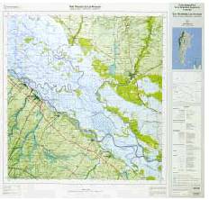
This was a pilot project completed by means of the photointerpretation of satellite images captured by the Thematic Mapper (TM) sensor on Landsat-5 during January and February 1994. The contours, hypsometry and relief shading were produced with the help of the Argentinian elevation database.
Institut Cartogràfic de Catalunya (ICC); Instituto Geográfico Militar de Argentina, Buenos Aires, Argentina.
Financed by: Instituto Geográfico Militar de Argentina, Ministerio de Defensa, Buenos Aires, Argentina.
Tourism-related mapping of the Pyrenees 1:50,000 (1993-2000)
Collaboration project intended for the development and diffusion of cartography in general. The project consist in the co-edition of transfrontier cartographic coverage of the Pyrenees at 1:50,000 scale, conceived as a series of thematic maps of interest to tourists and ramblers that aimed to cover the southern slopes of the Pyrenees in their enti-rety in 7 sheets.
Institut Cartogràfic de Catalunya (ICC); Randonnées Pyrénéennes, Tarbes-Ibos, France.
Financed by: Institut Cartogràfic de Catalunya (ICC); Randonnées Pyrénéennes, France; economic aid Interreg II of the European Union.
General map of the Pyrenees 1:1,000,000 (1991-1992)
The aim of this project was to publish a General map of the Pyrenees 1:1,000,000. The ICC participated in the production of the map, with the co-ordination and completion of the information concerning Catalonia. The map was published by the Institut Géographique National of France and the Instituto Geográfico Nacional of Spain with the transfrontier co-operation of the Pyrenean Work Community.
Institut Cartogràfic de Catalunya (ICC) and other participating institutions: Pyrenean Work Community (Andorra, Aragon, Aquitaine, Catalonia, Languedoc-Roussillon, Navarra, Basque Country, Midi-Pyrénées); Institut Géographique National (IGN), Paris, France; Instituto Geográfico Nacional (IGN), Madrid, Spain.
Financed by: Pyrenean Work Community (Andorra, Aragon, Aquitaine, Catalonia, Languedoc-Roussillon, Navarra, Basque Country, Midi-Pyrénées).
Map of the Mediterranean regions. Accessibility to transport infrastructures 1986-1988. Scale 1:3,500,000 (1990)
The aim of this project was to publish a map of the Mediterranean basin and the countries bordering this sea that showed the main transport infrastructures (motorways, roads, railways, ports and airports) and their accessibility (access time).
Institut Cartogràfic de Catalunya (ICC) and other participating institutions: European Centre for Regional Development (CEDRE); Comissió Interregional per al Transport a la Mediterrània; Institut Català per al Desenvolupament del Transport, Barcelona, Spain; Universitat Politècnica de Catalunya, Barcelona, Spain.
Financiacing: European Union; European Centre for Regional Development (CEDRE).
General tourist map of the Pyrenees 1:400,000 (1990)
The aim of the project was to publish the General tourist map of the Pyrenees 1:400,000. The ICC participated in the production of the map, contributing the information about Catalonia, in particular toponymic and tourist information. The map was published by the Institut Géographique National of France, the Instituto Geográfico Nacional of Spain and Randonnées Pyrénéennes, with the trans-frontier co-operation of the Pyrenean Work Community.
Institut Cartogràfic de Catalunya (ICC) and other participating institutions: Pyrenean Work Community (Andorra, Aragon, Aquitaine, Catalonia, Languedoc-Roussillon, Navarra, Basque Country, Midi-Pyrénées); Institut Géographique National (IGN), Paris, France; Instituto Geográfico Nacional (IGN), Madrid, Spain; Randonnées Pyrénéennes, Tarbes-Ibos, France.
Financiacing: Ministerio de Obras Públicas y Urbanismo (MOPU), Madrid, Spain; DATAR, France; Pyrenean Work Community (Andorra, Aragon, Aquitaine, Catalonia, Languedoc-Roussillon, Navarra, Basque Country, Midi-Pyrénées).
