
 Contact


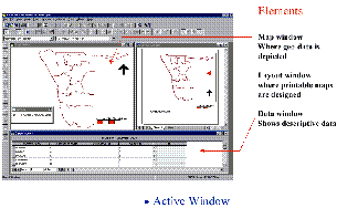
Course in Peru on the use of satellite images in cartography (2016)
Following the acquisition by the Peruvian government of an Earth observation satellite (PeruSat), Airbus DS GEO SGSA commissioned the ICGC a course on the use of satellite images in cartography, addressed to the technicians and workers of various civil and military agencies and institutions of Peru.
Institut Cartogràfic i Geològic de Catalunya (ICGC); Airbus DS GEO SGSA, Spain.
Technological transfer (2010)
Between 18th and 25th November 2010, the ICC, jointly with the Institut Geològic de Catalunya (IGC), taught the seminar titled "Introduction to radar technology and specific applications" for Venezuelan technicians training in the field of oil extraction. The aim was to showcase, with case studies, the technology and
methodologies: Interferometry and differential Interferometry with radar images to detect ground deformation (subsidence, displacement, deformation, etc.); radargrammetry techniques for generating digital elevation models; application of radar technology to detect volumes (natural oil deposits) in marine areas; introduction to polarimetry.
Institut Cartogràfic de Catalunya (ICC); Infoterra Servicios de Geoinformación, S.A.
Financed by: Infoterra Servicios de Geoinformación, S.A.
Scientific and technological cooperation (2009)
The ICC participated as a speaker in the lecture series titled "Modern conceptualization of digital photogrammetric processes in the context of large format aerophotogrammetric cameras", which took place in April 2009 at INEGI headquarters.
Institut Cartogràfic de Catalunya (ICC); Instituto Nacional de Estadística, Geografía e Informática (INEGI) de México.
Financed by: Instituto Nacional de Estadística, Geografía e Informática (INEGI) de México.
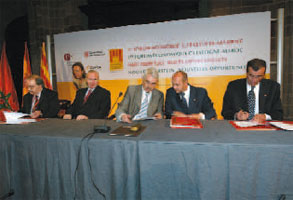
Comprehensive cartographic project in Morocco (2006-2008)
The ICC made a technical assistance of the ANCFCC and results were reported for future actions. In addition a study regarding the new geodetic network in Morocco. The ICC also established a protocol for quality control of the topographic maps of Morocco at 1:25,000 scale. That protocol was used by the ANCFCC to control the tasks subcontracted to third parties.
Institut Cartogràfic de Catalunya (ICC); Agence Nationale pour la Conservation Foncière, du Cadastre et de la Cartographie (ANCFCC), Rabat, Morocco.
Financed by: Agence Nationale pour la Conservation Foncière, du Cadastre et de la Cartographie (ANCFCC), Morocco.
Environmental monitoring and management system in Yunnan (2006-2007)
The ICC designed a geographic information system prototype for the monitoring and management of environmental alarms in the region of Yunnan. The hardware and software required was purchased, and the technical staff of the YEPB was trained to operate the system. Also an study of viability with a complete economic anaylisis, financial and environmental was given, considering the future challenges and the present reality.
Institut Cartogràfic de Catalunya (ICC); Yunnan Environmental Protection Bureau (YEPB), China.
Financed by: Spanish Government; FEV (Feasibility Study) funds.
Cartographic cooperation with the ANCFCC (2004-2007)
Cooperation in the scopes of cartographic and rural land registry information production, and in those of the training, research and technological transfer.
Institut Cartogràfic de Catalunya (ICC); Agence Nationale de la Conservation Foncière, du Cadastre et de la Cartographie (ANCFCC), Rabat, Morocco.
Financed by: Undertaken jointly by the participating institutions.
Scientific and technological cooperation (2004-2009)
Scientific and technological cooperation in the scope of remote sensing, geodesy, photogrammetry and GIS. The bases of this collaboration reside in the technical assistance, training and interchange of productive experiences.
Institut Cartogràfic de Catalunya (ICC); Instituto Geográfico Agustín Codazzi, Bogota, Colombia.
Financed by: Undertaken jointly by the participating institutions.
Technical assistance for the Republic of Namibia (2004-2005)
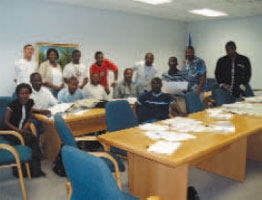
Technical attendance of the ICC to the CBS to implement a GIS. For the execution of the courses, the ICC had the collaboration of the Universitat Autònoma of Barcelona (Laboratory of Geographic Information and Remote Sensing, LIGIT), the Universitat de Girona (Service of SIG and Remote Sensing, SIGTE) and the Universitat Politècnica de Catalunya (Fundació Politècnica de Catalunya, FPC). The formation was conceived to address the necessities of the personnel of the CBS.
Institut Cartogràfic de Catalunya (ICC); Central Bureau of Statistics (CBS) of the National Planning Commission, Windhoek, Republic of Namibia.
Financed by: Agencia Española de Cooperación Internacional (AECI).
Advising on airborne altimeters (LIDAR technology) (2004)
Advising and training for the implementation of the airborne laser technology, LIDAR, with the purpose to successfully apply it in Mexico territory. These activities consisted in a course and in the development of two workshops at the headquarters of the INEGI and of the ICC, focused in the implementation of integral LIDAR solutions.
Institut Cartogràfic de Catalunya (ICC); Instituto Nacional de Estadística, Geografía e Informática (INEGI), Aguascalientes, Mexico.
Financed by: Instituto Nacional de Estadística, Geografía e Informática (INEGI), Mexico.
Advising for the technological resources (2004)
The objective was the delivery, by the ICC, of the results obtained from LIDAR data processing from equipment property of the INEGI.
Institut Cartogràfic de Catalunya (ICC); Instituto Nacional de Estadística, Geografía e Informática (INEGI), Aguascalientes, Mexico.
Financed by: Instituto Nacional de Estadística, Geografía e Informática (INEGI), Mexico.
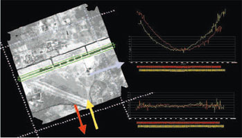
Radar interferometry (2004)
Development of a prototype and celebration of a seminary-workshop to present the potentialities or radar interferometry specially in the scope of the subsidences (using satellite images) and, in case of having the same technology on board in an airplane, the potential to generate cartography.
Institut Cartogràfic de Catalunya (ICC); Instituto Nacional de Estadística, Geografía e Informática (INEGI), Aguascalientes, Mexico.
Financed by: Instituto Nacional de Estadística, Geografía e Informática (INEGI), Mexico.
Formation in GIS technologies and census data use (2001-2002)
Formation project carried out for the Central Bureau of Statistics (CBS) of the National Planning Comission, Government of Namibia. The objective is to provide autonomy in the use of GIS technology to executive positions and technical personnel of the CBS, necessary for the elaboration, operation and dissemination of the census. The formation program has settled down in three parts: "Basics and concepts on cartography and GIS", "Cartographic context for a GIS. Origin and use of geographic data infrastructures" and "GIS to produce maps and Internet mapping. Census dissemination".
Institut Cartogràfic de Catalunya (ICC); The National Planning Commission, Namibia; Agencia Española de Cooperación Internacional, Madrid, Spain.
Financed by: Agencia Española de Cooperación Internacional.
