Antecedents
Natural risks are processes that periodically affect our territory with a great socioeconomic impact. For this reason, LLISCAT aims to be an updated inventory of land movements in order to:
- Awareness of the geographical extent of the problem and the socioeconomic impact.
- Establish causal relationships with the mechanisms that trigger (rains, earthquakes, among others) and determine the period of return of events.
- Encouraging coherent planning and territorial planning policies that are more harmonious with the environment (sustainable growth), as well as infrastructure planning that avoids conflicting areas.
- Address policies of prevention, protection and correction.
Organization of data
The Database is structured in three levels of information (only catalan):
- Level 1: basic information about the phenomenon (name, location, type of movement, photography, etc.).
- Level 2: more detailed information (morphometric data, geomorphological descriptions, causes, chronology, damages and actions performed, etc.).
- Level 3: Complete and advanced information only available for some landslides that have been thoroughly tracked.
Search type
General search: Within the general search, the following options are available, each with a drop-down.
- Comarca (county)
- Municipi (municipality)
- Nucli urbà (urban core)
- Unitat morfoestructural (morphostructural unit)
- Tipus de moviment (yype of movement)
- Any (year)
Advanced search: in the advanced search, the following options are available, each with a drop-down..
- Desencadenant (triggering)
- Estructures afectades (structures affected)
- Mesures correctores (corrective mesures)
- Instrumentació (instrumentation)
- Tipus de material mobilitzat (type of material mobilized)
- Unitat estratigràfica (stratigraphic unit)
- Volum en rang (m3) (volume in range)
Once the search has been completed, you must click on the name of the movement to see the different levels of information available in each case.
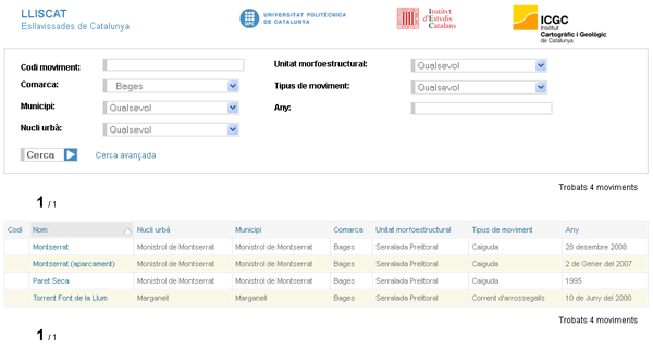
LLISCAT search / query interface with filtering in the Bages region

 Contact