
 Contact


The ICGC detects new constructions with the realization of LiDAR flights
The regulation of the constructions that are carried out in both urban and rural areas is vital for the sustainability of the territory.
Whether due to ignorance or to avoid paying taxes, some owners build new architectural elements such as houses, swimming pools or covered, without notifying the relevant administration, thus breaching existing regulations.
Also with the aim of evaluating the actions that have been carried out in a certain period, the detection of new constructions is considered a necessary task for the management of the territory.
Alternatives
Although new constructions could be detected by visual comparison between aerial photographs of different dates, this method would involve a high volume of work with results of little completeness, and the technique of subtracting images would hardly work, being necessary, in addition, the previous creation of orthophotos strict.
A more efficient solution would be to automatically compare elevation models obtained from LiDAR flights performed on different dates, thus detecting differences in height almost directly.
Hyperspectral sensors could also be used, but this method would be more aimed at detecting roof changes and some orthorectification would still be necessary.
Solution description
The ICGC technique to detect new constructions is based on conducting LiDAR flights on different dates, usually at an altitude of around 2,000 m and collecting 2 points / m2.
It should be noted that the ICGC applies a pass adjustment specifically developed to correct height errors that LiDAR points may have and thus achieve high precision
In any case, these flights are usually done in combination with an optical camera to be able to review and later classify, visually, the elements detected.
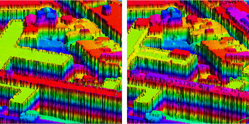
Once the LiDAR points are available, they are classified by distinguishing the buildings for each flight, applying algorithms that partially automate this task (adjustment of coplanar points, etc.).
Then the difference model is built and a series of operations are applied to distinguish, for example, points displaced more than 2 m (in height) between two capture dates. This not only allows you to define new elements, but also to have their size.
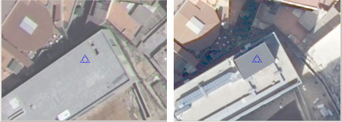
The delimitation of the elements that have changed is superimposed on aerial photographs, thus simplifying the detection and classification of the constructions that are sought. As it is georeferenced information, it can also be crossed with cadastral and administrative data to specify the actions to be taken.
This same technique can be used to calculate earth movements and other important volumetric changes in the territory.
Fulfilled projects
- Detection of new constructions for the Barcelona City Council
Related applications
- Evolution of coasts
- Topographic mapping
- Cadastral mapping
- Strict orthophoto
- 3D models of cities
