
 Contact


In areas characterized by a moderate seismicity, it is necessary to regionalize the seismic hazard, introducing concepts such as seismotectonic domains more than active faults. A first step of seismotectonic zonation is tectonic zonation. Various themes have been chosen for their ability to dscribve the present state and the different tectonic stages of structuration of the crust. The basic hypothesis is that the heterogeneity of the continental crust on the scale of the NE of Iberian Peninsula could explain the repartition and foifferent characteristics of the seismicity.
Geology of the Catalonia: Brief geologic description
Catalonia is located in the NE margin of the Iberia peninsula and at the NW area of the Mediterranean sea, just in the geodynamic context of the tectonic collision between the Eurasia and Africa plates. This collision has produced an increase of the thickness of the continental crust and the formation of the alpine orogeny and lately, the neogene thinning of the Valencia trough rift. The main catalan geologic units are following: Pyrennes, Mediterranean system, Ebro basin and the Transfer zone between the Pyrenees and the Mediterranean system.
a) Pyrenees are composed by granitoid massifs, gneiss and the paleozoic series that constitutes the Axial Zone, and by the Allochthnous covers of the Mesozoic and Paleogene series. The main tectonic episode of the Pyrenees chain formation is produced from the Upper Cretaceous until the Miocene age (50-25 MY) with the development of a W-E bending structure of the thrusts and folds. The Central and Eastern part of the Pyrenees chain, where is located Catalonia, is characterized by a thrusting system of an antiformal stack geometry that in the southward direction reachs the maximum shortening of 100 km. In this context, during the Upper Oligocene-Lower Miocene is developed the neogene intramontane basin of the Cerdanya.
b)Mediterranean system or Catalan Coastal Ranges, that constitutes the prolongation of the Iberian chain, is composed by the Paleozoic and Mesozoic cover materials and by the intermediate basins of the neogene and quaternary sediments. The structuration is individualized for a fault system of the NE-SW orientation. This system that cut the alpine structures, developing a horsts and grabens system, is produced by the european rift that constitutes the continental margin of the catalano-balear marine basin. This marine basin reachs a maximum depth of 2700 m in the abyssal plain related to the neogene rift.
c) The Tertiary Ebro basin, that constitutes the Pyrenees foreland is characterized by a thickness greater 3000m of the tertiary series (Paleogene to Oligocene times).
d) Between the Pyrenees chain and the Mediterranean system is located the Transfer zone with reactivated alpine faults and new faults of the Pliocene-Quaternary age of the orientation NW-SE. This system affects the eastern extremity of the Ebro basin. In this region are situated the Neogene-Quaternary volcanic area, the Emporda neogene basin and the Plio-Quaternary Selva basin.
Tectonic zoning
In areas characterized by a moderate seismicity like Catalonia, where is not possible identify the epicenters to the known active faults it is necessary from a point of practical view introduce the concepts as the seismotectonic domain rather active faults. The basic hypothesis is consider that the heterogeneity of the continental crust could explain the seismicity distribution
The tectonic zoning is the first step for the seismotectonic zonation procedure. This zonation takes into account the more representative parameters of the structuration of the crust, but not the analysis of the recent and present day tectonics (post Miocene). The variations of the specific geologic parameters allows to define a first homogeneous tectonic zoning.
These selected geologic and geophysic parameters are following:
- Mohorovicic discontinuity isobaths, such aas crustal thickness variation indicator.
- Hercynian deformation, moderate degree of deformation of the paleozoic sedimentary series in brittle domain with the thrusting development and in ductile domain with the schistosity development.
- Basement isobaths or bottom in depth that correspond to the roof basement.
- State of the deformation of meso-cenozoic sedimentary cover, as an indicator of the intensity of the alpine deformation.
- Neogene tectonics as indicator of the major cenozoic extensional processes.
- Evaporite triasic and tertiary levels which correspond to preferential decollement levels.
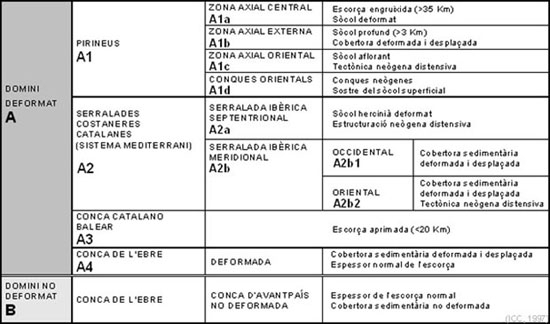
Tectonic zones definition
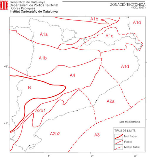
Tectonic zoning map of the seismicity
Seismotectonic zonation
The seismotectonic zonation may be obtained from the tectonic zonation is complemented by the seismicity distribution.
The zones proposed for the border line area are in agreement with the similar studies in France. Only three seismotectonic zones out of these eleven are defined only by seismicity distribution criteria.
The considered epicenters in the seismic hazard of Catalonia with the defined seismotectonic zones are shown.
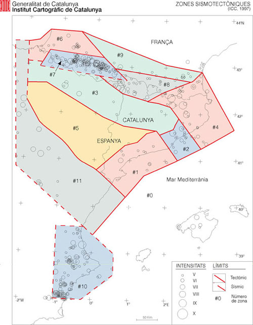
Seismotectonic zonation
