Contact


Research projects from other entities financed by state and European funds where the ICGC's experience in scientific tasks is requested.
Active projects
AMEPART. Análisis multidisciplinar y multiescala de los mecanismos de localización y reparto de la deformación cortical en convergencia oblicua

Values of the height of the basement in the Huelva sector
The relative movements in the limits between the tectonic plates constitute one of the main parameters that control the deformation that affects the rocks of these plates. One of the objectives of the AMEPART project focuses on the study of the distribution of deformation in a lateral zone of the north of the orogenic arch of Gibraltar (Sierra Bética). Better knowledge of the deformation distribution in this cross-section will allow more accurate interpretations to be made of the recent tectonic evolution of the Betic-Rifian orogen.
ICGC collaborates with the team to determine and analyze the focal mechanisms of earthquakes that occurred in the study area.
Project duration: 2019-2022 + 18 months.
Coordination: University of Pablo de Olavide.

This project is funded by the Programa de I+D+I Generación del Conocimiento y Retos Investigación 2018, del Ministerio de Ciencia, Innovación y Universidades (Ministerio de Ciencia e Innovación del Gobierno de España).
Geothermal - DHC. CA18129 - Research network for including Geothermal tecnologies into Decarbonized Heating and Cooling grids
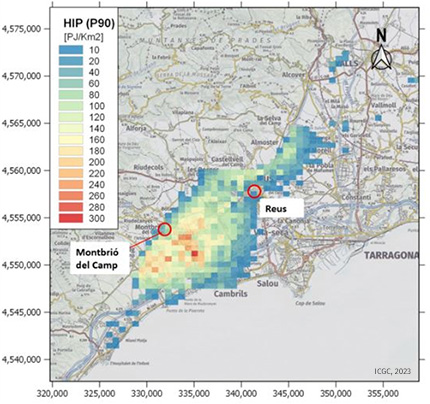
The resulting HIP (P90) values divided by the voxel area
The implementation of district heating and cooling networks in Catalonia with 100% renewable energy (with geothermal) is currently in its early stages of development (ex: 'DHC network 'smart' of heat in Olot; DHC Network Barri de l'Estrella in Badalona, etc.) compared to other EU countries (Austria, Germany, Denmark, etc.) and in this environment, it is important to capture experience from those countries in other areas of Europe that have greater knowledge. Geothermal energy in district networks is a sector with great growth opportunities. The project is aimed at the inclusion of GEOTHERMAL energy in heating and cooling systems in Europe through district networks, and with the aim of promoting the decarbonization of energy in the air conditioning sector. The main objective is to establish a network of organizations and researchers working to promote knowledge and/or use of surface and/or deep geothermal energy in urban heating and cooling networks in Europe.
Duration of the project: 2019-2024.
Coordinator: Mr. Gregor GOETZL, Action Chair.
Websites project: https://www.cost.eu/actions/CA18219/ i https://www.geothermal-dhc.eu/.
This project is funded by the COST ACTION Programme of the European Commission.
Advances in rockfall quantitative risk analysis (QRA) incorporating developments in geomatics


Terrestrial laser scanner
The main objective of the project is focused on reducing the uncertainties in the quantitative risk analysis (QRA) by improving the quality of the input data and the trajectory of the blocks. For this purpose, new calculation methodologies and tools for rockfall risk analysis and management will be developed.
The following specific objectives are proposed:
- Improvement of the performance of 3D models for landslide risk analysis.
- Development of high-resolution products for modeling rockfalls.
- Evaluations, quantification and criteria for risk management.
- Dissemination of results and 3D geoinformation.
Two of the three pilot areas to be analyzed are located in Catalonia, in areas where ICGC use to work (Montserrat and Castellfollit de la roca).
In this sense, ICGC collaborates directly in the develpement of th task “Assessment of rockfall frequency and magnitude”.
Project duration: 2020-2023.
Coordination: Universidad Politécnica de Cataluña (UPC). Sección de Ingeniería del Terreno, Cartografía i Geofísica. Departamento de Ingeniería Civil y Ambiental.
Project website: https://georisk.upc.edu/es
This project is funded by the Programa de I+D+I Generación del Conocimiento y Retos Investigación 2019, del Ministerio de Ciencia, Innovación y Universidades (Ministerio de Ciencia e Innovación del Gobierno de España).
Análisis de la erosión de suelos en terrenos de alta pendiente a diferentes escalas. Procesos físicos, auscultación y modelización de futuros cambios ambientales

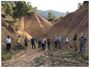
Field trip of the thematic Meeting of the project. Saldes.
(Image from https://eroslop.upc.edu/en/news-noticias).
The EROSLOP project aims to improve the understanding of soil erosion using an innovative multi-scale and multi-disciplinary approach. The project focuses on soil erosion on steep slopes and works at 3 different scales: slopes, first order basins and regional scale.
The study areas will be located in the central and eastern Pyrenees, although the model obtained can be applied to other basins of the Pyrenees to guarantee its transferability. The results obtained will serve to propose recommendations on land use planning and erosions mitigation.
Project duration: 2020-2023.
Coordination: Polytechnic University of Catalonia (UPC).
Project website: https://eroslop.upc.edu/en.
This project is funded by the Programa de I+D+I Generación del Conocimiento y Retos Investigación 2019, del Ministerio de Ciencia, Innovación y Universidades (Ministerio de Ciencia e Innovación del Gobierno de España).
IGCP-636 Phase II. ”Geothermal resources for Energy transition: Direct uses and renewable base-load power around globe”

Presentation during a webinar
The project is an extension of another previous project, granted to the same members, called IGCP project “Unifying international research forces to unlock and strengthen geothermal exploitation of the Americas and Europe” (2016-2019). The main objective is to establish a network of organizations and researchers to exchange knowledge and experience on the main lines of research and evaluation of deep geothermal resources, shallow geothermal resources and the promotion and dissemination of the resource. On the other hand, it is intended to have a framework for work and collaboration to prepare project proposals at an international level oriented to geothermal energy.
The 2 main leaders of the project have invited the ICGC to join the project as one more member, along with other participants.
Project duration: 2020-2025.
Coordination: University of Medellin.
Project website: https://igcp636.com/.

This project is funded by the International Geoscience Programme (IGCP), de la UNESCO 2019.
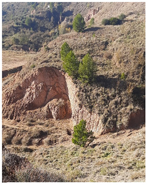
DIAPERNO. Procesos geomorfológicos en sistemas salinos activos. Levantamiento, subsidencia, erosión química, deslizamientos, alteración en drenajes
Mass movements
DIAPERNO is a multidisciplinary project that aims to study the processes linked to active saline structures and their effects. Processes include: 1) ground deformation related to salt flow induced by different mechanisms (tectonic charge, differential overload charge, erosive discharge); 2) the impact of soil deformation on landslide development and drainage network modification; 3) the development of sinkholes in salt extrusions with and without caprocks; and 4) denudation by dissolution of salt. These processes will be explored in 4 cases of active saline structures, one of which is the Cardona diapir (in the Salt Valley).
Duration fo the project: 2021-2023.
Coordinator: Universidad de Zaragoza (UNIZAR).
This project is funded by UNESCO's International Geoscience Programme (IGCP) 2019.
PALEOBARCINO-II. Cambios ambientales, paisajísticos y adaptabilidad humana en un llano litoral mediterráneo durante el Holoceno: el sector de Montjuïc en el pla de Barcelona

Boring hole of the Gandhi Gardens (Poble Nou)
The PaleoBarcnio-II project aims to carry out a paleogeographic reconstruction of the coastal plain of Barcelona throughout the Holocene. From a deeply multidisciplinary approach, it proposes, from the sedimentary study, the identification of the changes in the configuration of the coast and the formation of the deltaic bodies of the Besòs and Llobregat, looking for the causality of the changes (climatic variability vs. human impact). It is proposed to analyze the past interrelationships between the environmental changes of these highly dynamic coastal environments and the human communities that inhabited them. In addition, the project studies the process of modeling the Barcelona landscape, the result of the interaction of natural factors and human uses of space and resources. The project, coordinated by the University of Barcelona, involves various universities, research institutes and administration services.
ICGC will have access and will be able to use the data that will integrate the project.
Project duration: 2021-2024.
Coordination: University of Barcelona.
This project is funded by the Programa de I+D+I Generación del Conocimiento y Retos Investigación 2020, del Ministerio de Ciencia, Innovación y Universidades (Ministerio de Ciencia e Innovación del Gobierno de España).
Análisis pluridisciplinar e integración de series multi-archivos para el desarrollo de modelos espacio-temporales de inundaciones históricas

Concept of multi-archive paleoflood integration
The objective is to define and apply a multidisciplinary methodology that contributes to the generation of time series of floods in mountain areas, among other characteristics, subjected to nival dynamics. Variation in surface hydrological conditions that determine the performance of river systems leads to significant environmental, socioeconomic and flood risks. As a result, the study expects to determine if paleofloods could be attributed to warm or cold weather periods, higher or lower humidity, related to variations in atmospheric circulation on a regional climate scale.
The interest for ICGC lies in the study of the control exerted by the melting of the snow cover in floods. ICGC participates in the INUNCAT Plan contributing with its knowledge and forecast of snow melting.
Project duration: 2021-2024.
Coordination: University of Barcelona.
Project website: http://www.palaeo.org/.
This project is funded by the Programa de I+D+I Generación del Conocimiento y Retos Investigación 2020, del Ministerio de Ciencia, Innovación y Universidades (Ministerio de Ciencia e Innovación del Gobierno de España).
High-resolution imaging of the crustal-scale structure of the Central Pyrenees and role of Variscan inheritance on its geodynamic evolution

This project is the extension of GEOPIRI3D (CGL2017-84901-C2-2-P), in which ICGC also collaborated by providing gravimetric data in the Cerdanya basin.
The recent IMAGYN project (PID2020-114273GB-C22) intends to continue with that investigation, taking into account two premises:
- Study in more detail and adjust the special interest areas by integrating new geophysical data to reduce uncertainties.
- Characterize both the upper and lower crust of Central Pyrenees (up to the upper part of the lithospheric mantle) from the expansion of the interest area to encompass both foreland basins.

Seismometer, recorder, charger and battery
The main objective is to obtain a high-resolution image of the cortical structure of the Central Pyrenees, a necessary image to analyze the role played by the Variscan structure and the heterogeneity of the basement materials and the upper materials from the petrophysical and structural point of view. The comparison with previous data of Cadí basin will allow to analyze the pre-Alpine configuration of these basins and to reconstruct their geodynamic evolution together with the associated granitic bodies.
The ICGC will collaborate with the realization of a passive seismic profile in the Cerdanya area.
Project duration: 2021-2025.
Coordination: IGME-CSIC.
Project website: https://geo3bcn.csic.es/index.php/research/projects/ongoing-projects/2071-imagyn.
This project is funded by the Programa Estatal de Generación de Conocimiento y Fortalecimiento Científico y Tecnológico del Sistema de I+D+i, Plan Estatal de Investigación Científica y Técnica y de Innovación 2020, (Ministerio de Ciencia e Innovación del Gobierno de España).
GOLDFINGER. Arquitectura orogénica varisca: recursos estratégicos y proyección ambiental sostenible

The team of University of Salamanca will carry out the subproject “Late Variscan strategic ore deposits: structural and geophysical fingerprints”. In this subproject, a 3D model of a gneissic dome with different associated mineral deposits will be created, by integrating different high-resolution geophysical data, including seismic, gravimetry and magnetism, as well as regional geology. The results will be used to evaluate a regional-scale model connecting gneissic domes and coeval structures, thermal gradients, and mineral deposit formation.
The participation of ICGC in this project will allow to put into practice methodologies at a high depth of investigation (passive seismic), as well as to develop knowledge in gravimetry in another field, such as mining exploration.
Project duration: 2021-2025.
Coordination: University of Salamanca. Geology department.
This project is funded by the Programa Estatal de Generación de Conocimiento y Fortalecimiento Científico y Tecnológico del Sistema de I+D+i, Plan Estatal de Investigación Científica y Técnica y de Innovación 2020 (Ministerio de Ciencia e Innovación del Gobierno de España).
NSOURCES. Nuevas aproximaciones a la caracterización de fuentes sísmicas y su integración en modelos de peligrosidad sísmica basados en fallas. Estudio de casos en zonas de actividad baja a intermedia en el este de Iberia.

Seismic hazard models, generally based on historical and instrumental seismicity, can be improved by integrating information on sources (active faults) obtained from a combination of geological, paleoseismic, geodetic and geophysical studies. The NSOURCES project will provide new information that could help to improve/update the hazard studies carried out within the framework of the SISMICAT plan and it will also contribute to propose new studies and to provide and improvement in the knowledge of seismic risk in Catalonia.
Project duration: 2021-2025.
Coordination: University of Barcelona – Faculty of Geology.
This project is funded by the Programa Estatal de Generación de Conocimiento y Fortalecimiento Científico y Tecnológico del Sistema de I+D+i, Plan Estatal de Investigación Científica y Técnica y de Innovación 2020, (Ministerio de Ciencia e Innovación del Gobierno de España).
Cartography, delimitation and geopolitics in Spain (XVII-XI centuries)
The general objectives of the research project are aimed at generating knowledge about cartographic expression, referring to the territorial delimitation of Spain, at different levels of administration: regional, provincial, regional and municipal. The chronological period is extensive, although the emphasis is placed in the century of great changes in the political map of the country: the nineteenth century. This project will expand the cataloguing and value some maps of the collection of the map library, disseminate the Map Library of Catalonia in national, Spanish and international areas of history of cartography.
Duration of the project: 2022-2025.
Coordinator: University of Lleida.
This project is funded by the State Program for the Generation of Knowledge and Scientific and Technological Strengthening of the R+D+i System, State Plan for Scientific and Technical Research and Innovation 2021 (Ministry of Science and Innovation of the Government of Spain).
EPYSIM. Eastern PYrenees Seismic IMaging
The main objective of the project is to perform high-resolution seismic noise tomography in the area of La Garrotxa and La Selva to characterize the transition between compression in the Pyrenees and extension to the Mediterranean. Geophysical and geological studies are planned to have a subsoil structure model at regional and local scales that allows, on the one hand, 3D modeling of seismic wave propagation to identify structures related to the volcanic field of La Garrotxa and, on the other hand, characterize the seismogenetic zone of La Selva to obtain the relationship between seismicity, active faults and crustal structure.
Duration of the project: 2023-2026.
Coordinator: Intitute of Geosciences of Barcelona (CSIC).
This project is funded by the State Program for the Generation of Knowledge and Scientific and Technological Strengthening of the R+D+i System, State Plan for Scientific and Technical Research and Innovation 2022 (Ministry of Science and Innovation of the Government of Spain).
CLIMAAX. CLIMAte risk and vulnerability Assessment framework and toolboX

The project aims to respond to one of the needs in adaptation to climate change such as Climate Risk Assessment (ARC) at regional scale. The aim is to provide a standardised framework for this risk assessment and a toolbox that facilitates the design and implementation of regional climate change adaptation plans, to provide a more effective response to climate emergencies. The project foresees the creation of a Community of Practice (CoP) that allows CLIMAAX to expand the entities participating in the co-creation of the ARC beyond the project Consortium.
Duration of the project: 2023-2026.
Coordinator: Deltares.
This project is funded by the European Programme of Horizon Europe.