
 Contact


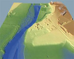
LIDAR flight over flood-prone areas in Andorra (2006)
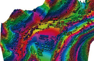
The ICC made a flight capturing data with the LIDAR laser altimeter covering an area of 6,000 ha with a scan density of 1 point/m2. Data was then processed and manually edited, obtaining the digital elevation models (terrain and surface) to delimit the floodprone areas of the Principality of Andorra by means of subsequent hydraulic studies.
Institut Cartogràfic de Catalunya (ICC); Ministeri d’Ordenació Territorial (Govern d'Andorra), Andorra la Vella, Andorra.
Financed by: Ministeri d’Ordenament Territorial (Govern d'Andorra).
AWARE (2005-2008)
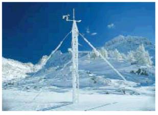
The aim of this project was to offer innovative tools for monitoring and predicting the volume of water available in basins by measuring the quantity of snow. In this way medium and long-term water flow predictions can be made, with a view to more sustainable water resource management.
The ICC was responsible for the development of a GeoService which, in accordance with all the requirements of the INSPIRE program, was capable of analyzing global and local data in order to calculate, file and distribute the information drawn from the snow data.
Institut Cartogràfic de Catalunya (ICC); Istituto per il Rilevamento Elettromagnetico dell’Ambiente, Italy; Politecnico di Milano, Italy; WSL-Institut für Schnee-und Lawinenforschung SLF, Switzerland; Institut für Hydraulik, Gewässerkunde und Wasserwirtschaft Technische Universität Wien, Austria; University of Slovenia, Slovenia; Remote Sensing Data Engeneering, Italy; Universitat Jaume I, Castelló, Spain.
Financed by: 6th Framework Programme of the European Union.
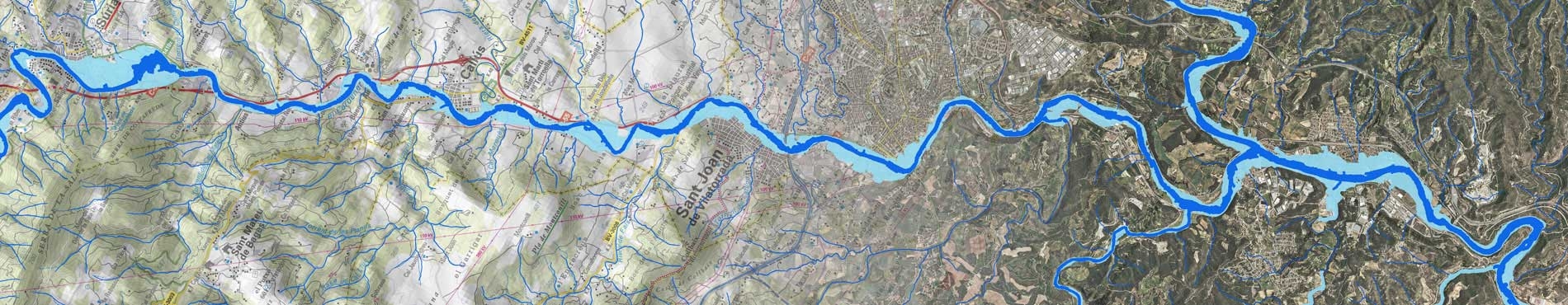
LIDAR flight over the River Savio (2005)
The ICC made a flight capturing data with the LIDAR laser altimeter, covering the River Savio, with a scan density of 0.5 points/m2. Data was then processed and manually edited, obtaining the digital elevation models (terrain and surface), to delimit the flood-prone areas of the basin of this river by means of subsequent hydraulic studies.
Institut Cartogràfic de Catalunya (ICC); Regione Emilia-Romagna, Bologna, Italy.
Financed by: Servizio Geologico, Sismico e dei Suoli, Direzione Generale Ambiente e Difesa del Suolo e della Costa, Regione Emilia-Romagna.
Measuring, monitoring and managing sustainability: the coastal dimensions (1998-2002)
The objective is to complete a multidisciplinary study of sustainable development in a group of test areas on the west coast of India, taking account of hydrological, geological and biological considerations, as well as socioeconomic and cultural aspects. The ICC will participate in the synthesis of the study model and in the construction of monitorization tools based on GIS technology.
Institut Cartogràfic de Catalunya (ICC); Tata Energy Research Institute, India; Laboratorio Nacional de Engenharia Civil, Portugal; Universidade Nova de Lisboa, Portugal; Università degli Studi di Trieste, Italy; National Institute of Oceanography, India.
Financed by: Directorate General XII for Science, Research and Development of the European Union.
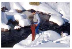
A multidisciplinary global approach of groundwater flows in karstic areas and its consequences for water resources and environment studies (1995-1996)
The aim of this project was to research radioactivity and trace elements in experimental karstic systems in France and Catalonia and their implications for the evaluation of resources and the environmental problems.
Institut Cartogràfic de Catalunya (ICC); Geofluides-Bassins-Eau (Centre National de la Recherche Scientifique CNRS), Montpellier, France; Universitat Autònoma de Barcelona, Spain; Aristotle University of Thessaloniki, Greece; Laboratoire Souterrain (Centre National de la Recherche Scientifique CNRS), Montpellier, France; Istituto di Geochronologia of the Consiglio Nazionale delle Ricerche (CNR), Pisa, Italy.
Financed by: Directorate General XII for Science, Research and Development (Programme: Human Capital and Mobility) of the European Union.
Antarctica (1994-1996)
For this project was to use SAR (Synthetic Aperture Radar) images from the ERS-1 satellite over the Antarctic region. The possibility was explored of estimating ice thicknesses based on the application of interferometry. Automatic extraction of Thematic information was also completed. The potential of the radar images in order to discriminate between water, ice and rock was shown on the island of Livingston. The potential of photogrammetry with respect to the study of glacier dynamics was also studied. In the same way, measurements were made of the volume of ice lost by a glacier over a two-year period when information was collected.
Institut Cartogràfic de Catalunya (ICC); Departament de Geomorfologia (Facultat de Geologia, Universitat de Barcelona), Spain.
Financed by: Comisión Interministerial de Ciencia y Tecnología, Madrid, Spain.
Exchange of matter and fluid motion in karstic media (1993-1995)
The aim of this project was to demonstrate the interest of radon and natural radioactivity as characteristic parameters of water flow in a variety of aquifers. The experimental part of the project was developed in 11 hydrological systems.
Institut Cartogràfic de Catalunya (ICC); Laboratoire Geofluides-Bassins-Eau (Centre National de la Recherche Scientifique CNRS), Montpellier, France.
Financed by: Directorate General XII for Science, Research and Development (Programme: Human Capital and Mobility) of the European Union.
Integrated Basin Studies (IBS) (1993-1998)
This project was conceived to make an integrated study of some previously selected sedimentary basins in Europe and to carry out dynamic modelling. The study included basins in both expansion and compression regimes. The sedimentary response in the tectonic regime was modelled and the compaction and flow of fluids in the sediment was studied.
Institut Cartogràfic de Catalunya (ICC); Institut Français du Pétrole, Rueil-Malmaison, France; Elf Aquitaine Production, France; Vrije Universiteit, Amsterdam, The Netherlands; Universitat de Barcelona, Spain; Institut de Ciències de la Terra Jaume Almera (Consejo Superior de Investigaciones Científicas CSIC), Barcelona, Spain; École Normale Supérieure, Paris, France; Centre National de la Recherche Scientifique (CNRS), Montpellier, France; École Nationale Supérieure de Géologie, Nancy, France; Universität Tübingen, Germany; University of Newcastle, United Kingdom; Groupement pour l'Étude des Structures Souterraines de Stockage, Palaiseau, France; Universität Friedericiana Karlsruhe, Germany; Norsk Hydro, Bergen, Norway.
Financed by: Directorate General XII for Science, Research and Development (Programme: Joule II) of the European Union.
