
 Contact

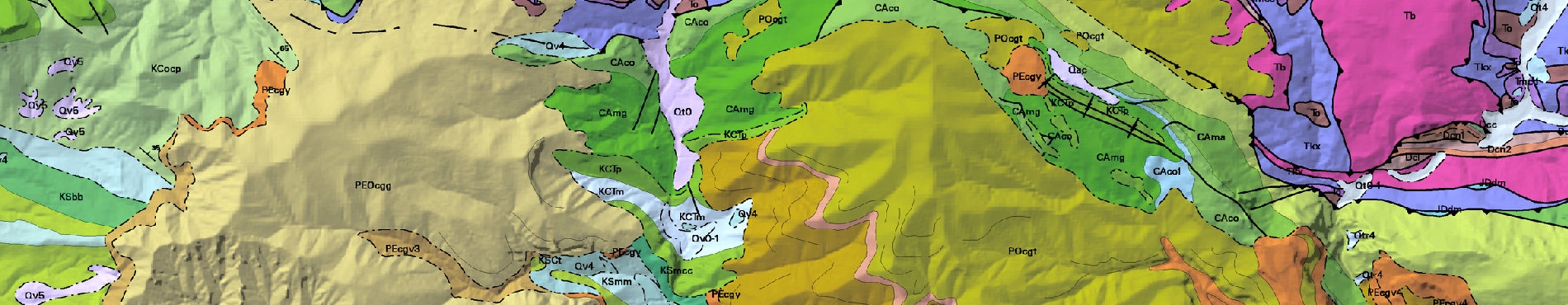


The Geological map of Catalonia 1:50,000 (MG50m v2, 2016) collects all the geological information of synthesis and continuous of all the territory, based on information available from the Department of Environment and Housing, Department of Territorial Policy and Public Works, Cartographic Institute of Catalonia, Geological Institute of Catalonia and the Geological and Mining Institute of Spain in 2016.
SHP format
The ZIP file that is downloaded includes the following SHP files:
- mg50mv20sh0fl1.shp: Faults and folds (lines).
- mg50mv20sh0cl1.shp: Contacts (sedimentary, metamorphic, igneous and hydrotermal) and geomorphologic elements (lines).
It contains the following fields:- CODI_CAS: Object type encoding.
- DESCRIPCIO: Description of the object.
- mg50mv20sh0gp1.shp: Geological units (polygons).
It contains the following fields:- CODI_CAS: Object type encoding (Epigraph unit).
- DESCRIPCIO: Description of the unit.
- ClasLitoEd: Classification according to lithology and age.
- ERA: Geological era.
- PERIODE: Geological period.
- EPOCA: Geological epoch.
- EDAT: Geological age.
- MET: Type of metamorphism.
- PROTOLIT: Protolith of the metamorphic unit.
- EDAT_MET: Geological age of metamorphism.
- mg50mv20sh0ap1.shp: Anthropogenic deposits (polygons).
It contains the following fields:- CODI_CAS: Object type encoding (Epigraph unit).
- DESCRIPCIO: Description of the unit.
- EDAT: Assignment age: Anthropocene.
- mg50mv20_01ca.pdf: Specifications for the ESRI Shapefile (SHP).
- mgc50mv02sh0_00ca.style: ESRI style library.
- MG50mv20sh0_00ca.lyr: Layerfile file for loading the recommended visualization for data and symbolization.
The geodetic reference system of the distributed data is ETRS89 UTM31N.
Legend of the geological map 1: 50,000 [PDF, 3 MB; catalan, April 2022]
This cartography is under the Creative Commons Attribution 4.0 International license.![]()
More info
