Presentation
Knowledge of the nature of the subsoil is a key to successful design and development of any public work or building. A suitable geological survey of the land is the starting point in which the designer support to make the most appropriate decisions to ensure security, stability and durability of a work.
In the city of Barcelona and its area of influence a large number of public works and buildings of Catalonia are made. There is also a significant amount of information of the works that have been doing in recent decades.
In this context the realization of a comprehensive geotechnical map of Barcelona and its environment that allowed both by the scale of work as the information is necessary to place each new construction project in its geotechnical frame. Geotechnical Map of Barcelona had as objective to provide a first insight geotechnical of the terrain where each work arises. It was designed to use it primarily for the draft or preliminary study, but it also could serve to establish the basis from which to project the pre-campaign survey to final design. Note that at any time the geotechnical map of Barcelona is not intended, nor can, replacing concrete recognition to do in each of the projects.
The territorial scope of this mapping does not coincide with the municipality or the county of Barcelones, but has chosen the area where they held most public works projects and construction. It extends from the mouth of the Llobregat and the coastal plain of northeastern Besos. The inner boundary is marked by the Collserola chain.
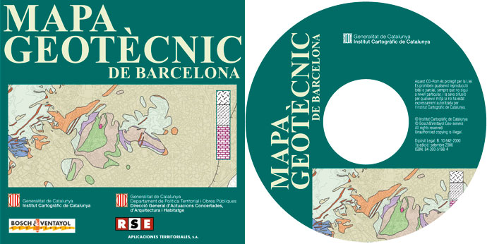
In this first edition, the Geotechnical Map of Barcelona comes in CD-Rom format because it was considered that this facilitates the consultation of the various thematic maps that are included in the job. Despite this support allows application zooms enlargement and reduction, all work has been planned to be used at the scale of 1:25 000.
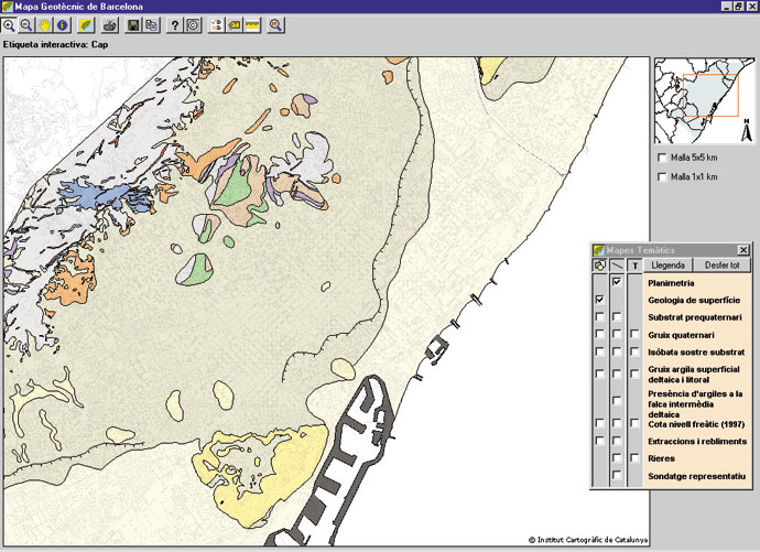
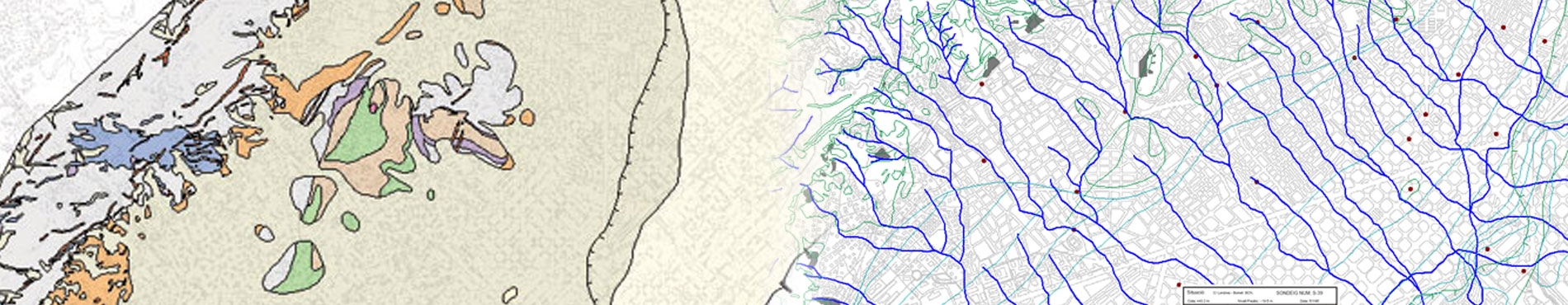
Viewing the geotechnical map of Barcelona with topography and geology of surface
The CD-Rom is composed of memory, maps and a set of columns of the most representative sampling.
The memory consists of introduction, methodology and geological and geotechnical materials description also includes a description of hydrology and seismic zonation.
The maps can be displayed correspond to:
- Surface geological map
- Geology Map of Pre-Quaternary substrat
- Map thick of Quaternary sediments
- Map of isobaths of Pre-Quaternary substrat
- Map of thickness of the surface clays and silts, in coastal and deltaic plains
- Identification map of deltaic areas with greater presence of clays in the intermediate wedge
- Isoline map of the water table (1997)
- Map of streams
- Map of anthropogenic fillings
- Location map of the most representative bore holes
Lithological columns of 80 representative surveys, distributed throughout the mapped surface are also included. On the other hand, can make virtual borings anywhere on the map.
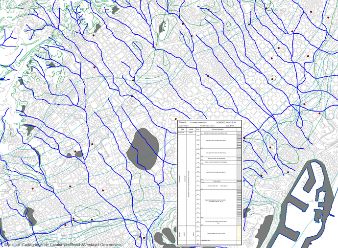
Example of exploitation of Geotechnical Map of Barcelona with planimetry, lithologic contacts, streams, borings, surveys lithological column, anthropic filled quarries and piezometries
Geology and geotechnics of Barcelona
The area shown corresponds to the existing territory between the projected mouth of the Llobregat and the coastal plain to the northeast of the mouth of the Besòs, having as limits the sea and the coastal mountain range. Except as referring to the mountainous terrain and the deltas of the two rivers, this surface coincides with called Barcelona plain .
The plain of Barcelona is a morphological platform, gently sloping towards the sea, linking gradually to the northwest to maritime slope of the Collserola chain, which has at Tibidabo (512 m) high point more. This level corresponds to a piedmont plain, with an approximate surface area of 65 km2, and its slope is higher at the foot of Collserola (10-20°) and gradually decreases towards the sea (2-4º).
The continuity of the platform between the Llobregat and Besòs, is altered in two major areas. On the one hand, by the presence of known reliefs by Serrats Rovira, encompassing a range of hills located between Horta and Sarria: Peira Hill (138 m) hill Rovira (261 m), the Carmel (267 m), the Creueta (249 m), the Puget (181 m) and Monterols (121 m).
On the other hand, on the waterfront, south of the city of Barcelona, the block of Montjuïc (189 m), accompanied by a series of minor elevations such as Mount Tàber, where he founded the ancient Roman Barcino, and rises other small hills today almost disappeared by urban progression city. These include, for its geological implication, since in many cases are Pliocene outcrops substrate: Hill of Ollers (C / dels Escudellers and C / Nou de Sant Francesc), peak of Falzies (Llotja de Mar), the vinyeta (Spain square) and tip Convent (Parc de la Ciutadella). West of Montjuïc, and in the town of Hospitalet de Llobregat, there may be mentioned Hills Torrassa, Planes, Can Serra and Sant Feliu, the latter already in Cornellà.
East of Besòs, there is also a mountain range: Llefià, Hill Carig, etc., which are then together with the reliefs of the coastal mountain range in Montigalà and the Conreria, and link to Montgat hill.
The deltaic plains of Llobregat and Besòs, and developed the coastal strip between the two deltas are areas of very smooth morphology with very inferiors remaining 1%, usually located less than 10-15 m above sea level. The Besòs delta has an approximate surface area of 15 km2, while the Llobregat is much larger, of the order of 92 km2, although this mapping has only been studied her left margin.
Separating the Barcelona plain of deltaic and coastal areas, there is a very steep slope, which can be followed in many places, although urban development has tended to make it disappear in the city center. This slope or geomorphological step is still perfectly observable between Cornellà and Hospitalet. This sector has a height of about 20 m, and its margin runs the railroad and his foot the Infanta channel.
The slope is blurred in the neighborhood of Bordeta by the urban fabric, but still can be recognized in very central locations, such as street Gravina, in the upper reaches of the Rambla, or unevenness that makes the Via Laietana or Jonqueres street at the foot of the square of Urquinaona.
The western slope surrounds the square of the Glories Catalanes, and from this point goes north through Sant Andreu, where height is again Important, the order of 15 m. Also in this case the railroad continues its path.
Cartography of the Institut Cartogràfic i Geològic de Catalunya (ICGC) and Bosch i Ventayol Geoserveis, under a CC BY 4.0 license
More info

 Contact